Sims Bayou is a combination of a natural and channelized bayou. The bottom of the bayou is made up of interlocking concrete blocks, and is flat, unlike the other channelized bayous that have a central deep channel. And this made it tough to kayak because, even with recent rains, it was very shallow, especially west of MLK Boulevard. My kayak only needs about a foot or two of depth but there were several sections where I was scraping the bottom.
Sims Bayou at Scott. It looks deep!Downtown view on the hike down to Sims BayouWalked through Sunnyside
I took the Metro Red Line south to the end of the line and started hiking toward Sims Bayou at Scott where I put in and started paddling. There was very little flow and it was very shallow.
Views from the Bayou
I had to portage around one very low bridge a mile or so east of Cullen.
Oops! Not going through that.Dragging around the bridge.
Saw the usual wildlife, turtles, birds and lots and lots of big fish.
After kayaking a bit over six miles, paddling the whole way since there was almost no current, I pulled out at Reveille Park in Southeast Houston. From there I hike to the southern end of the Metro Purple line for the ride home.
Pullout spot in Reveille ParkWaiting for the train.
Got an early start walking to the Ensemble/HCC Metro station and was on a train around 6:00 AM (foolishly trying to beat the heat) heading north.
Metro red line train at 6:00 in the morning….
Took it to the end of the line and then starting hiking west on Crosstimbers. Five miles (or so) later I was on the White Oak Bayou Hike/Bike trail looking for a way into the bayou.
Nice place to put in. Just north of 43rd street.
The bayou was flowing nicely. I had found a NOAA website that shows flow rates and depths of the bayous around Houston (NOAA) . It showed that the bayou was a bit over it’s nominal low depth from the recent rains.
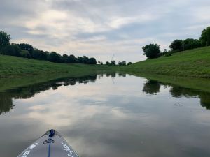
In the water and moving nicely!Typical view from the water.
This was my second “channelized” bayou and, like Braes Bayou, the current was moving nicely, making for easy paddling. But there is NO SHADE at all so I’m glad it was early in the morning.
Wildlife admiring the graffiti.
Did not see as much wildlife as on the wilder bayous (as expected) but did see some birds, a few turtles and the ever-present fish. And there are some big guys in there. And something causing the fish to jump, one almost ended up on my boat.
Short section of rapids…. fun!
For the first 8 miles or so the bayou moved nicely with even a few short sections of rapids. The cross-section of the bayou is not a uniform depth. The sides are quite shallow, sometimes even dry. I had to stay in the deeper center part which is only about 10-12 feet wide so I had to pay attention to keep from bottoming out. On the plus side, there were almost no obstructions (i.e. tires, trees, shopping carts).
Little White Oak Bayou – a small tributary.
I took one short side trip a few hundred yards up Little White Oak Bayou which enters into WO Bayou just west of the I-45, I-10 interchange.
First good view of downtown.The concrete (and the flow!) ends a mile or two from downtown.
As I neared downtown the flow slowed to almost no noticeable movement and the concrete ended. It got prettier and harder. Typical.
The underside of a bridge – Harvey remnants?And someone lost their garbage can.Buffalo Bayou!Allens Landing and the end of my kayak adventure.
After about 10 miles of so White Oak Bayou empties into Buffalo Bayou just across from Allens Landing. I paddled over and pulled out. Buffalo Bayou was moving well from all the recent rain. Then a short walk to the UH Metro station and heading home.
The only kayak-able part of Buffalo Bayou I had not done was a 5 mile section from the West Belt to Briarbend Park. This turned out to be a surprisingly fun little section with several small rapids and cool animal sitings.
Put-in spot under the West BeltNo idea…
I biked to Briarbend Park, left my bike and hiked out to the West Belt. There is a pretty good put-in spot under the freeway (i.e. no mud, no brambles).
Cool tree #1So that’s where the storm drains go…Cool tree #2And, just in case you forgot you are in the city.Harvey damage? Clearly someone had a bad day.
I saw lots of birds and the largest turtle I have ever seen – it’s shell was at least 3 feet across. And a very large fish – at least 3 feet long – surfaced next to my boat. The bayou is teeming with fish.
Fishing!And flying
The pullout point is just past some rapids which made for an exciting exit.
Rapids!Pull-out spot.
And it is important to hit this pull-out as the next one is 3-4 miles downstream.
For my first attempt at a “channelized” section of a Bayou, I picked Braes Bayou from just inside Loop 610 back to Hermann Park. Large swaths of Houston Bayous were turned into concrete ditches in the middle of the last century for flood mitigation (the efficacy of which is open to debate).
My hiking setup – ready to start inflating.Ready to put in….… down these “escape” stairs.
Getting in (and out) of these sections isn’t always easy. Fortunately most of the bayous have escape stairs (for people who fall in, I would guess) every half mile or so. And that is how I entered (and exited).
The view from the water.Heading under another bridge.
I expected this to be less fun because the view is pretty monotonous, but I was surprised. The water moved much faster than in the more natural sections so I had to pay more attention to stay in the middle (the depth is not constant, the sides are very shallow) and there were several small rapid sections. And…. any day on the water is a good day!
Requisite selfie1Medical Center.Pull-out spot.
I missed my planned egress point because I was moving so fast and had to exit at the next available spot. I had enough fun to try another channelized bayou – thinking of White Oak Bayou.
To get to Green’s Bayou in far east Houston I left my bike at home and took the kayak and trailer on Metro Rail north to the final stop and started hiking east along Crosstimber Road. After 10 miles or so I arrived at a bridge over Greens Bayou (Ley Road) where I had heard I could gain access to the bayou:
Right. After 20 minutes of bushwalking through steep brambles I managed to get to a spot where I could inflate my kayak and drop down to the water.
A flatish spot under the bridge where I could inflate the kayak.
Greens Bayou is the wildest of the Houston Bayous. It is wide, deep and has lots of wildlife as it winds it’s way south to join Buffalo Bayou about five miles west of north Galveston Bay. I saw two alligators – did not get a picture of the second one as I was too busy paddling away!
One of the two alligators I saw…. the other one was a LOT bigger.
And, while it was quite a bit more bucolic than Buffalo Bayou, there was still the odd bit of urban junk in the water.
Weird bit of junk floating in the bayou
And there was no current – it was like paddling in a lake.
Wide, deep and no current.Detritus from a past flood.Selfie!Old dock – no way to get out here.
I kayaked about five miles and was just beginning to think about looking for a pull-out when I passed a tiny little side channel. When I went up it to explore I found myself at an “official” access point in Strickland Park. Of course there were no signs on the bayou so I found it purely by chance.
Lovely pull-out spot. No mud! No brambles!
And I enjoyed a snack waiting for my lovely wife to come pick me up. No more hiking today!
My biggest bike/hike/kayak trip yet was to far west Houston. I left my bike at the beltway and hiked west to Hwy 6 where I managed, with some difficulty, to get the kayak into the water where I discovered that the water was only a few inches deep. For the next mile or so I had to hop out out every 100 feet and drag my kayak over logs, rocks and shallows.
Bike locked and ready to hike west to Highway 6.Another log!Dragging through the shallowsAnd over rocks.
Slowly, as side channels added more water, the depth increased and the portaging sections got farther apart.
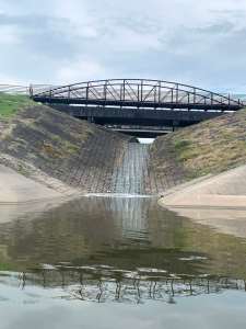
Deeper water…finally!!Pretty section of the bayouBayou waterfall!Tree roots – obviously the water is higher sometimes.
The bayou had a lot of obstructions which generated some small rapids in a few places which added a bit of excitement and fun to what was, at the beginning, a real slog.
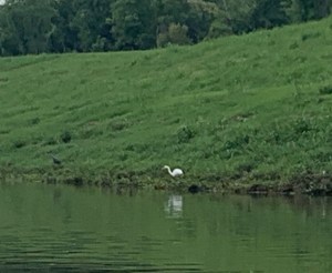
Following an egret east.
Got back to my bike after 6 or 7 miles of bayou kayaking where I began a long ride home.
Pull-out spot under the West Belt. Time to start biking home.
Biked up to downtown and entered Buffalo Bayou heading east. I took the Bayou to just west of Turkey Bend, where I started seeing commercial barge traffic and heavy industry on both sides of the Bayou. The end of the Houston Ship Channel is only a couple miles east.
My hike/bike trailer systemDowntown view from the bayouThe Wortham Center (Ballet, Opera)Ballet bridge over the bayou
As the bayou heads east it gets wider and deeper becoming a commercial waterway.
The bayou really opens upSelfie time!A “waterfall” on the bayou
I made it to just west of Turkey Bend where a large barge was being loaded with scrap metal and I turned back to a lovely little take-out spot with a nice dock.
View of downtown as I headed back to my pull-out spotNo mud! No rocks! A real dock!
From here I hiked back to my bike at the Sabine Bridge.
For my second kayak trip I used my new bike trailer to bike down to MacGregor Park where I left my bike and started kayaking Braes Bayou east. Braes Bayou is “channelized” west of here but from here east it is quite natural.
Put-in spot near Macgregor ParkFairly clean water but some debrisPretty spot
At one point I took a side channel through a culver.
Side channel
Pretty wild on the other side of the tunnelSelfie!
I saw a little wildlife, mostly turtles and birds.
Some birdsFishing bird
As the bayou nears Buffalo Bayou (within a mile or so) it opens up and becomes more industrial.
Working boat near Buffalo BayouWorking barge about 1/2 mile from Buffalo Bayou
At this point I decided things were getting too commercial so I turned around and found a pull out spot in Mason Park.
Pull out spot in Mason Park
I packed up the kayak and humped back to my bike in Macgregor Park.
For my first test of my inflatable Kayak I hiked to Buffalo Bayou and the West Loop (610). Things got off to a rocky start when I slipped and fell in the mud trying to get the kayak into the water. My first lesson on kayaking Houston Bayous – access is often problematic.
The Galleria from the bayouGoing under the loop
I saw numerous birds. I saw the largest woodpecker I’ve ever seen with a bright red head (but, unfortunately did not get a picture). And turtles. Lot and lots of turtles.
Bird in flight…… and posing.Big turtle watching me
I was pretty pleased with the kayak. The five mile or so hike was not great – the kayak hip belt rides too high and, since the back is frameless, you carry all the weight on your shoulders. Five or 6 miles is probably the limit for carrying it.
The requisite selfie!
I paddled into downtown and then back against the current (which isn’t much) to get to a pullout point just west of the Sabine Bridge.
Another train hike – this one to the end of the newer purple line. Like most of my hikes to the south this one starts from Herman Park and heads east along Braes Bayou.
A memorial along the bayouLooking north from Herman ParkTunnel under MacGregor StreetPelicans on the bayou