
Another train hike – this one to the end of the newer purple line. Like most of my hikes to the south this one starts from Herman Park and heads east along Braes Bayou.


Another train hike – this one to the end of the newer purple line. Like most of my hikes to the south this one starts from Herman Park and heads east along Braes Bayou.

So I got the idea of hiking to the ends of the Metro Commuter Rail lines and then taking the train back home. It makes a nice way to end a long walk – in air conditioned comfort! This route took me southwest along Braes Bayou then south to just outside the loop before heading east back to the terminus of Metro Red Line. This was also my second hike with my new Arc Blast 55 backpack.


In 2020 I started doing some more Houston area hikes in preparation for my (aborted ) attempt on the AZT in the spring. This first one was a walk north to the end of the Metro red line (and then I took the train back – smart, right?).


These first series of hikes in Houston were in preparation for my Colorado Trail hike in the fall of 2018. This was a one way hike east as far as I could go along the Braes Bayou trail (and a little beyond).


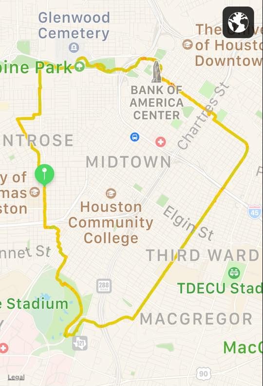
This was my first longish hike around Houston. It was in July and very warm. This course basically circumnavigates Montrose/Midtown. Starting in Montrose you head south the Herman Park, hook up with the Braes Bayou trail along MacGregor for a mile or so before heading north on the Columbia Tap Trail. The CT trail loops back west heading toward downtown where it ends. You then wind through downtown to catch the Buffalo Bayou trail along Allen Parkway and then back south to complete the loop.


This was my longest hike yet in Houston – over 16 miles. The route followed the White Oak Bayou Trail to where it ends (near Fairbanks-North Houston Road). I nearly made it to the beltway (my goal) but it was hot so I stopped a bit short after 5 hours.


This hike basically parallels 290. Starting from Montrose I headed north till I hit the White Oak Bayou Trail and followed it to then end (just inside the beltway).


I wanted something that I could backpack and also ride my bike. I settled on the Sevlor K5. It seemed like a pretty good compromise. At 26 lbs it is not too heavy and the reviews were mostly positive.

It cost about $250, quite a bit cheaper that some of hardshell collapsable kayaks.
The backpack, unfortunately, is not really designed for long hauls. There is no frame and the hip belt rides high so it is basically a rucksack. With water, food, etc. the pack ends up weighing north of 30lbs which is on the heavy side for a rucksack. I modified the hip belt by attaching a more comfortable belt from an old pack. Even with this modification, hiking for more than 5 or 6 miles would be rough.


The kayak is great. It does not track as well as a standard kayak and rides a bit higher but it is perfectly adequate. And it is a really cool design. The pack turns into a quite comfortable seat. The included paddle is a bit cheap but works alright if you are careful with it. The pump is very light and pumps on both strokes so the three kayak chambers are quickly filled.
I quickly realized that if I wanted to get the kayak more than 5-6 miles from home I would need to use my bike. Riding with the kayak on my back works but I still need to hump the kayak back to the bike after kayaking. I wanted to essentially add wheels to the kayak so I could pull it with my bike or push it when hiking. I found a bike trailer I thought would work, the Sepnine Bike Cargo Trailer.

The trailer is 11.5 lbs and collapses so I can put it on my kayak when I reach my put-in spot.


After only three eventful days, and 52 miles I aborted my 2020 AZT attempt. A combination of wanting to see my Dad who had just entered hospice care (he is still going strong as I type this), the AZT Association recommending stopping thru-hikes because of Covid-19, and worrying about Roberta being on her own during the pandemic all contributed to the decision. But it wasn’t easy, the trail was great and I felt good.
I flew to Tucson on March 16, the day after Trump announced “this is a very contagious virus. It’s incredible. But it’s something that we have tremendous control over.” IAH was nearly deserted but my plane was about half full.

I arrived in Tucson, unpacked my pack, packed a few travel items in a USPS shipping box and Lyfted to a downtown post office. From the post office I hiked a couple of miles to the Greyhound station for my bus trip to Sierra Vista. Things really felt weird when I realized I was the only person on the bus.

After an eventful bus ride (an accident blocked out original route and I had to talk the bus driver into diverting by promising to navigate for him – he did not have a smart phone or a map), I finally arrived in Sierra Vista and hiked a couple of miles to my hotel where I was informed that all the restaurants in town were only doing take-out.
Arranged for a Lyft at 6:15. News is getting worse – San Francisco is on mandatory lock-down. Ohio cancelled today’s primary. And Trump is still crazy. Talked to Bert last night and learned that Dad has gone into hospice. The AZT organization sent out an email to members. Basically the trail is open – be careful.


Lyft guy got me to the trail about 6:40 AM and I walked the ~2 miles to the start at the border – dropping my pack on the way. The trail start is actually on the other side of the “big, beautiful” border wall, which is basically a wire fence with a big hole in it. So I was, briefly, an illegal immigrant.

On the way back I met two thru-hikers (Allen from Minnesota and another guy).

This was a tough day! Up for 6 miles – topping out at 9,000 feet. Close to a 4,000 foot day. Left the border at 7:30. Reached Bathtub Spring (8.4) at 12:30 and camp at 4:00.


Saw a group of Border guys doing a training hike and met two other hikers (Rory and Bec) from Flagstaff. Bec grew up in Houston and lived in Montrose , “where all the cool kids lived.”


Beautiful day but windy! Saw a group of wild turkeys and some deer. Lots of water so far. This was a 15.5 mile day (13.6+1.9) and tough for the first day.


Totally different day. It rained pretty much all day though not hard. I thought this was supposed to be a desert? In the first two days I have walked in snow and been rained on – in southern Arizona in March!

I got to camp about 3:00 and as I set up the tent next to a tiny, almost dry creek and then the rain started up again. It rained hard for a couple hours. In a break I stepped outside my tent to see that I was now next to a raging river about a foot from my tent. I hurriedly stuffed everything back in my pack and scrambled uphill in fading light to higher ground. Got my tent up just as it started dumping hard again.
The rain finally let up about 4 AM but then the wind came up. Gusts collapsed my tent a couple of time but it sprang back both times. A cold, windy, wet night and not much sleep.
Beautiful day of hiking! Almost like the trail is making up for yesterday – sunny and cool. Met another thru hiker, Jacob, and hopscotched with him most of the day.

With all the rain there was water everywhere – too much water. Not a complaint you often hear in southern Arizona. Spent most of the day wading numerous small streams.

The weather was perfect for hiking and I felt good so decided to push on to Patagonia, a 19 mile day.

I briefly got cell coverage in the morning and called the Stage Stop Inn and made reservation for this evening. Then called Bert. We talked it over and I decided to abort. Not happy but it is probably the for the best.

Met several thru-hikers in Patagonia. A couple were continuing on and a couple had decided to stop.

A few days after I exited the trail, this from AZT.org : “…If you have already started and can be fully self-sufficient for 800 miles and/or rely on assistance from a single friend or family member, consider all of your options very carefully. Bailing out and returning another time may be the best choice. The AZT will be here for you to explore in the future”.
So here is my plan for the AZT:

Getting to the start is a little tough, the trailhead is on the Mexican border 25 miles due south of Sierra Vista, Az. I plan to fly into Tucson, take a Greyhound bus to Sierra Vista, spend the night and get a trail shuttle or Uber to as close to the trail head as possible. You have to hike about 3 miles to get to the official start.

Even though the trail is not as popular as the big trails (PCT and Appalachia Trail) they still have ~200 people finish it every year. The vast majority are north-bounders who hike in the spring (like me!) but a few people do it north to south in the fall. The spring option is more poplar because there is usually more water and the weather tends to be a bit better. Though, there may still be snow on the trial north of the Grand Canyon even as late as I will be there (early May).
Speaking of weather… at the southern end when I start the highs should be in the 60-70’s and the lows in the 40’s. By the time I hit Flagstaff, the highs will be in the 60’s and the lows in the 30’s. And the Grand Canyon will be about the same, maybe 5 degrees cooler. I’m hoping most of the snow will be gone from the trail by then but you never know.
I will hopefully be a bit lighter on this hike than the Colorado Trail, thanks to a new pack I got for Christmas (thanks to my lovely wife!). For details on my equipment check out Jason’s AZT Equipment List, but here is a summary:

So my base will be just at 14 lbs (and I’m hoping to squeeze another ounce or two out to get under 14 lbs!).
Well…. we did it. We bought a canal boat in France. We spent a summer on a Locaboat Penichette 1165FB in 2017. We really liked the 1165FB so we contacted Locaboat and asked if they had any for sale. Which is how we ended up on “Decize” for a week in August. Decize is a 1996 1160FB which is nearly identical to the 1165FB. She is 23 years old and has been in rental that entire time, so the hull is showing some wear but the engine is only ~10 years old and most of her systems are quite a bit newer.

Here are some thoughts on how we selected our boat and more details about Decize.
There are two basic styles of (pleasure) boats that are used on the canals in Europe, motor cruisers and barges. The motor cruisers can have fiberglass or steel hulls (most of the dutch models are steel). They typically have a single inboard diesel engine, are 10-15 meters in length (30-45 feet) and draw 1 to 1.5 meters (3 – 4 feet).

The other major category are barges. A lot of these were commercial barges that have been converted. They almost alway have steel hulls and many of them have hulls that are 100 years old. There are also quite a few built-to-spec barges that have more recent hulls. They are usually much longer than motor cruisers, 20 meters (60 feet) is not unusual.

We looked at lots of used boats of both types and decided we didn’t really want either. The motor cruisers are nice (and sea worthy enough for light coastal cruising) but they tended to be expensive for what we needed and the internal layout didn’t support guests as nicely as boats we have rented. The barges were nice and some are affordable but handling a >20 meter boat scared us both.
So… we finally decided just to buy a boat exactly like the Locaboat Penichette we rented for the summer. We contacted Locaboat and they had a ~20 year old 1160FB for sale. We booked “Decize” for a week in August to check her out, and as a bonus, they would apply the rental fee to the sale. And ….. we bought her!
Though Locaboat does not sell their boats new, Decize probably had a value of around €250,000 new. At 23 years old (she was commissioned in 1996) she was offered for €70,000 which was in our price range and should allow us to invest some money for upgrades and repairs.

She is 11.6 meters (38.1 feet) long, 3.85 meters (12.6 feet) wide and draws only 0.85 meters (2.8 feet). Her “air draft” (height above the water) is 2.90 meters (9.5 feet). These last two numbers are important as some of the canals are shallow and some of the bridges are very low.
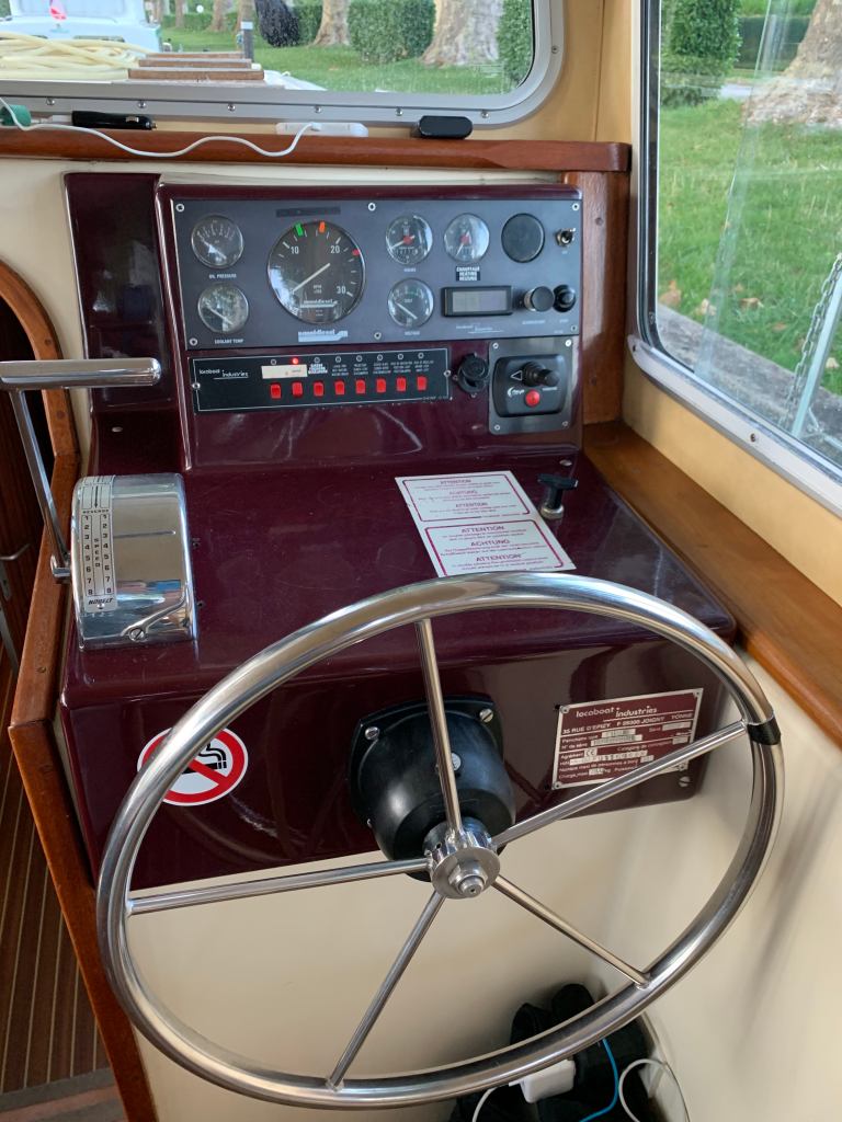
She has a 2008 (16,700 hours) inboard 50HP diesel engine. There is a cabin heater that supplies heat throughout the boat. The heater uses the same diesel fuel tank as the engine to heat the boiler.
Decize has a 420L (110 Gallon) fuel tank. The spec sheet (above) gives fuel use (under power) as 4.0 L/Hr, but our experience with these boats is that it is much closer to 2 L/Hr. Top speed is about 10 Km/Hr (about 5.5 kts). No, that is not a typo – top speed is about 6 mph. We generally cruise at 6-8 Km/Hr (and many of the canals have speed limits in this range). Assuming 2L/Hr consumption at 6 Km/Hr she has a range of about 1200 Km (745 miles).
The fresh water tanks have a capacity of 700 L (185 Gallons) which, for two people used to boating is well over a week of use. Decize has no black water or grey water tanks… everything goes overboard. This is legal in France but we expect that to change so we want to explore adding at least black water tanks. Unfortunately, there is no infrastructure (pump stations) in most of the smaller marinas and until that changes people will continue to dump overboard.
I haven’t figured out all of this yet, will have to wait till the coming summer trip. As typical there are two battery banks, a house battery and an engine starting battery.
The house battery consists of six 12V batteries wired series/parallel to get 24V. Total capacity is 118*3 = 352 Ah (20 Hr). This runs all the lights, refrigerator, water pump, toilets, etc. The starter battery is a single 12 v (75 AH) battery. Having two voltages is a little weird. Not sure how this works. Based on the breaker panel labels, the alternator has multiple windings and charges both batteries when the motor is running.

There is a battery charger that charges only the house battery (?) when the boat is connected to shore power. That would be strange but usually battery chargers cannot do multiple voltages.
There is a main breaker panel for the DC systems located in the closet of the main salon.

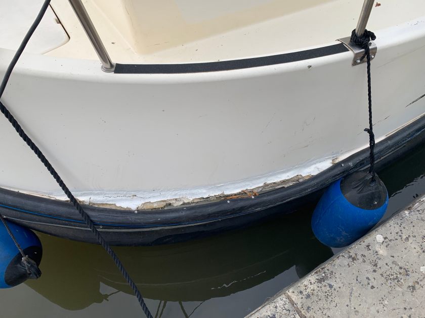
Decize definitely shows he wear and tear of being in rental for 20 odd years. The damage is entirely superficial but we would like to have her repaired and painted.
As the spec shows, Decize has three berths and two heads. The fore head is an integrated shower/head/sink. The aft head is split into two small rooms, a toilet room and shower/sink room.


.
