BMT Equipment

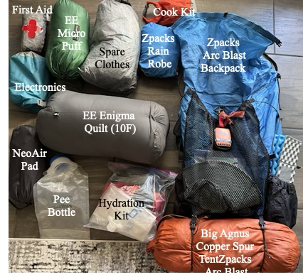
Pack Weight (Base Weight)

Base weight is everything you carry excluding food, water and fuel. Weight is VERY important. The difference between carrying a 25 lb pack versus a 45 lb pack up a 2,000 foot climb is huge and has gotten even more important as I have aged. And, since I have to fly to the start, I have a travel bag that holds my pack and poles and converts to a pack liner when I arrive.

My base weight is 15.0 lbs so with 10 lbs of food and 2L of water I will still be under 30 lbs when I start a section.

The “Big Three”

This is the pack, tent and sleeping bag and pad. My backpack is on it’s last legs – the material is starting to delaminate but I’m counting on the liner to give me one more big hike before I retire it.

ItemTypeWeight (Lbs)
BackpackArc Blast1.8
Travel Bag/LinerZpaks0.2
Sleep PadTherm-a-Rest NeoAir 0.8
Sleep QuiltEE Enigma (10F)1.5
 TentBA Copper Spur UL 12.3
6.5
Cooking/Hydration/Toiletries/First Aid

My cook “kit” consists of a titanium mug, a canister stove and a spork. For water I use a Platypus filter, a couple of 2L collapsable bladders and a 4L “dirty” water bag (plus some hoses). Toiletries consists of a toothbrush, a poop kit (trowel, wet-wipes), reading glasses and sunscreen and… that’s about it.

ItemTypeWeight (Lbs)
Cook kit (minus fuel)0.4
HydrationPlatypus1.2
Toiletries1.0
First aid kitIncluding Epi-Pen0.8
3.4
Clothing (not worn)

The weather looks to be mild so I can leave my long johns at home. I always bring emergency clothing (micropuff, rain gear) .

ItemTypeWeight (Lbs)
Hat/glovesZpacks beanie0.4
Rain GearZpacks Rain Robe/wind pants1.2
MicropuffEE Torrid Apex Jacket1.0
Sleep wear Shorts, t-shirt0.7
Socks, buffs, etcToe socks0.3
3.6
Electronics/Misc

I am taking two external 10,000 mAHr batteries. Each one should recharge my Iphone 15 twice and keep my headphones and keyboard charged.

ItemTypeWeight (Lbs)
Headlamp0.1
Wireless Keyboard0.3
Batterie (10AHr, 2)Nitecore NB100000.7
SPOT Satellite TrackerGen 30.3
Headphones/cables0.1
1.5

Benton MacKaye Trail Plan

Getting to the Trail

The southern terminus of the BMT is about 2 hours north of Atlanta. My plan is to fly into Atlanta on March 27, take the MARTA red line 2o miles or so north to the Sandy Springs Station and then have a shuttle take me (~70 miles, 2 hours) to the Springer Mountain trailhead.

I arrive around 10:30 so am hoping I can get a least a few miles down the trail the first day.

Section 1 (Springer Mountain to Thunder Rock CG, 94 Miles, 6 Days, 23,000 Ft):

The trail starts near Springer Mountain in the Chattahoochee-Oconee National Forest, about 80 miles north of Atlanta. The start of the trail is within a quarter of a mile of the start of the much more famous Appalachian Trail. In fact, the two trails cross several times and basically take a parallel path north.

BMT Section 1

I hope to get 6-8 trail miles on the day arrive so I can complete the remaining 90 miles in the following 6 days. Five of those will be in Georgia, and the last in Tennessee, finishing at Thunder Rock CG on the Ocoee River around noon on April 2. From there I will either hitch or try to find a shuttle for the ~7 miles of highway to Ducktown for my first zero day.

DayDateMilesClimb (ft)BMT Mile
027-Mar8.07508.0
128-Mar15.04,10023.0
229-Mar14.53,30037.5
330-Mar14.92,30052.4
431-Mar14.24,05066.6
501-Apr16.33,25082.9
602-Apr10.91,60093.8
703-AprZERODucktown

Resupply options are limited in Ducktown (just a Dollar General) but there is a real grocery store about 4 miles south in Mackaysville if I can figure out a way to get there.

Cell coverage in the first section is pretty good. The figure below shows voice (green) and data (purple) for each day. Importantly it shows voice coverage at the end so I may be able to contact a shuttle.

Elevation profiles and cell coverage in Section 1
Section 2 (Thunder Rock CG to Fontana Dam, 95 Miles, 6 Days, 25,500 Ft):

The second section winds northeast along the Tennessee/North Carolina border for 95 miles, ending at Fontana Dam, a TVA dam on the Little Tennessee River. The first day on this section is longer than I would like but it allows me to get to a real campground (with running water!).

BMT Section 2

DayDateMilesClimb (ft)BMT Mile
804-Apr17.53,400111.3
905-Apr15.83,560127.1
1006-Apr15.34,150142.4
1107-Apr15.03,700157.4
1208-Apr16.04,600173.4
1309-Apr16.63,700191.5
1410-AprZEROHike Inn

There is a resort complex (lodge, campground, marina), Fontana Village Resort right on the trail as you approach the lake at the end of this section. However, the day I plan to arrive, Wednesday, April 9, the entire resort is booked for a private event (even the campground?). So this very convenient rest stop is not available. And, on top of that, the cell coverage is terrible here.

So….. my plan is stop at the Tapoco Lodge (about 10 miles from the Fontana Village) and arrange a shuttle pickup from The Hike Inn , a hiker-friendly hostel about 9 miles east of the dam.

Elevation profile and cell coverage in Section 2.
Section 3 (Fontana Dam to the End, 99 Miles, 7 Days, 20,250 Ft):

The last section is entirely in the Great Smoky Mountains National Park (GSMNP) where free camping is not available and campsites have to be reserved. I plan on reserving these from The Hike Inn and am hoping that the Giant Orange Turd’s attack on the national park service does not impact my plans.

BMT Section 3

DayDateMilesClimb (ft)BMT Mile
1511-Apr13.22,400207.6
1612-Apr15.12,200222.7
1713-Apr15.73,200238.4
1814-Apr14.74,150253.1
1915-Apr14.53,100267.6
2016-Apr10.04,000277.7
2117-Apr12.01,200289.7
3.0Hostel

Cell coverage (with T-Mobile) is very poor. I will not have cell coverage at any of my campsites and rarely during the day. But there is coverage near the end so will be able to contact Standing Bear Hostel to arrange a pickup if I don’t want to walk 3 road miles to their place.

Elevation profile and cell coverage in Section 3.

I plan on staying a night at the hostel before shuttling in to Knoxville for my return flight to Houston in April 20.